
Bestand:NY 30-30A junction from south.jpg

Grootte van deze voorvertoning: 800 × 482 pixels. Andere resoluties: 320 × 193 pixels | 640 × 386 pixels | 1.024 × 617 pixels | 1.280 × 771 pixels | 2.748 × 1.656 pixels.
Oorspronkelijk bestand (2.748 × 1.656 pixels, bestandsgrootte: 1,82 MB, MIME-type: image/jpeg)
Beschrijving
| Beschrijving |
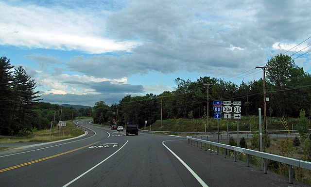
English: Southern terminus of New York State Route 30A at intersection two miles (3.2 km) north of Schoharie, NY, USA. View taken from New York State Route 30 (NY 30) as it approaches intersection from the south; NY 30 continues north by turning right.
Southbound NY 30 comes into the intersection via a long downgrade, descending almost 500 vertical feet (150 m) in the mile (1.6 km) north of this intersection, requiring a stop sign. Until the late 2000s the intersection was more oblique and accidents frequently occurred when traffic on southbound NY 30 realized, too late, that they had to stop and traffic on northbound NY 30 and 30A did not. Heavy trucks have also been banned from using NY 30. Nevertheless, in October 2018 this became the site of a stretch limo crash that killed 20 people when the driver, coming in from the right, failed to stop at high speed and went into the parking lot whose entrance is seen at left, where the limo struck an SUV. Two pedestrians in the parking lot, as well as all in the limo, died. |
||
| Datum | Genomen op 25 juni 2012, 08:16 | ||
| Bron | New York State Route 30 | ||
| Auteur | Doug Kerr from Albany, NY, United States. Cropped and edited slightly by Daniel Case prior to upload | ||
| Toestemming (Hergebruik van dit bestand) |
Dit bestand is gelicenseerd onder de Creative Commons-licentie Naamsvermelding-Gelijk delen 2.0 Unported
|
||
| Andere versies | Unedited Flickr original |
| Cameralocatie | | Deze en andere afbeeldingen in: OpenStreetMap |
|---|
De geografische informatie van dit bestand werd achteraf geschat.
De locatie kan daarom wat onnauwkeurig zijn. Het verifiëren en verfijnen van deze coördinaten wordt sterk aangemoedigd. |
Bestandsgeschiedenis
Klik op een datum/tijd om het bestand te zien zoals het destijds was.
| Datum/tijd | Miniatuur | Afmetingen | Gebruiker | Opmerking | |
|---|---|---|---|---|---|
| huidige versie | 11 okt 2018 06:29 | | 2.748 × 1.656 (1,82 MB) | Daniel Case | Went back to my original version and just did various lightening tricks—lifted shadows, added some brightness, added exposure etc.—to the *ground*, leaving the sky alone, so it didn't get ridiculously blown out like the last edit. |
| 10 okt 2018 06:21 |  | 2.748 × 1.656 (1,16 MB) | Mandruss | added lots of brightness and some contrast | |
| 8 okt 2018 21:10 |  | 2.748 × 1.656 (1,62 MB) | Daniel Case | {{Information |description ={{en|1=Southern terminus of {{w|New York State Route 30A}} at intersection two miles (3.2 km) north of Schoharie, NY, USA. View taken from {{w|New York State Route 30}} (NY 30) as it approaches intersection from the south; NY 30 continues north by turning right. Southbound NY 30 comes into the intersection via a long downgrade, descending almost 500 vertical feet (150 m) in the mile (1.6 km) north of this intersection, requiring a stop... |
Bestandsgebruik
Dit bestand wordt op de volgende pagina gebruikt:
Globaal bestandsgebruik
De volgende andere wiki's gebruiken dit bestand:
- Gebruikt op en.wikipedia.org