
Bestand:Gaza conflict map.png
Geen hogere resolutie beschikbaar.
Gaza_conflict_map.png (612 × 300 pixels, bestandsgrootte: 27 kB, MIME-type: image/png)
Beschrijving
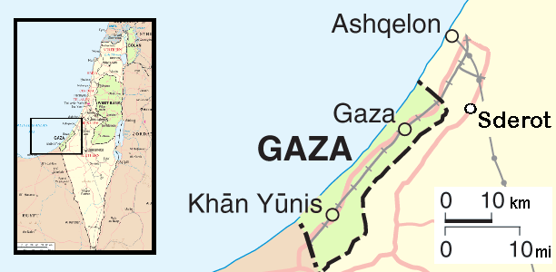
| Beschrijving | Map of the conflict area around the Gaza strip |
| Datum | |
| Bron | self-made, from this PD image |
| Auteur | Orlovic |
Licentie
| Ik, de auteursrechthebbende van dit werk, geef dit werk vrij in het publieke domein. Dit is wereldwijd van toepassing. In sommige landen is dit wettelijk niet mogelijk; in die gevallen geldt: Ik sta iedereen toe dit werk voor eender welk doel te gebruiken, zonder enige voorwaarden, tenzij zulke voorwaarden door de wet worden voorgeschreven. |
Bestandsgeschiedenis
Klik op een datum/tijd om het bestand te zien zoals het destijds was.
| Datum/tijd | Miniatuur | Afmetingen | Gebruiker | Opmerking | |
|---|---|---|---|---|---|
| huidige versie | 12 apr 2009 12:23 | | 612 × 300 (27 kB) | Ogre | removed border as per request |
| 22 dec 2008 14:35 |  | 627 × 315 (32 kB) | Orlovic | == Summary == {{Information |Description=Map of the conflict area around the Gaza strip |Source=self-made, from this PD image |Date=May 2007 |Author= Orlovic }} == Licensing == {{PD-se | |
| 22 mei 2007 22:45 |  | 627 × 315 (32 kB) | Orlovic | {{Information |Description=Map of the conflict area around the Gaza strip |Source=self-made, from this PD image |Date=May 2007 |Author= Orlovic }} Category:Maps of Israel |
Bestandsgebruik
Dit bestand wordt op de volgende pagina gebruikt:
Globaal bestandsgebruik
De volgende andere wiki's gebruiken dit bestand:
- Gebruikt op ar.wikipedia.org
- Gebruikt op br.wikipedia.org
- Gebruikt op ckb.wikipedia.org
- Gebruikt op cs.wikipedia.org
- Gebruikt op cs.wikinews.org
- Gebruikt op cy.wikipedia.org
- Gebruikt op da.wikipedia.org
- Gebruikt op de.wikipedia.org
- Gebruikt op de.wikinews.org
- Gebruikt op en.wikipedia.org
- Gebruikt op en.wikinews.org
- Gebruikt op es.wikipedia.org
- Gebruikt op es.wikinews.org
- Gebruikt op eu.wikipedia.org
- Gebruikt op fa.wikipedia.org
- Gebruikt op fr.wikipedia.org
- Gebruikt op he.wikipedia.org
- Gebruikt op hu.wikipedia.org
- Gebruikt op id.wikipedia.org
- Gebruikt op it.wikipedia.org
- Gebruikt op it.wikinews.org
- Israele: raid aerei in risposta ai razzi. Hamas: la tregua per noi è finita
- Israele: raid su Jabalia. Hamas contatta Hezbollah
- Israele: politica richiede una "difesa attiva" per destituire Hamas
- Striscia di Gaza: iniziata l'offensiva israeliana
- Striscia di Gaza: Israele prepara l'assalto via terra. ANP pronto a riprendere il controllo dell'area
- Striscia di Gaza: 400 morti. Voci di una tregua, poi Hamas smentisce
- Striscia di Gaza: Israele lancia volantini. Centrale nucleare a rischio razzi
- Striscia di Gaza: Israele inizia l'offensiva via terra
- Striscia di Gaza: terzo giorno di offensiva terrestre israeliana. Razzi a 40 km da Tel Aviv
- Striscia di Gaza: tregua umanitaria di tre ore. Olmert blocca la «terza fase»
- Template:Operazione Piombo fuso
- Striscia di Gaza: colpita sede Unrwa. Per l'Egitto la tregua è vicina
- Striscia di Gaza: Israele dichiara tregua unilaterale. Hamas: «Per noi non conta»
Globaal gebruik van dit bestand bekijken.